Big Basin Redwood State Park (Sunday 8/19/01)

[Update: photos from this hike - full loop taken, archives of all hikes]

Note: the shorter loop is about 7 miles, not the 5-6 miles I had previously stated.
Dear Friends,

Prepare for the longest and perhaps the most scenic hike thus far.  First of all, dont be scared with the word "longest", there's a backup loop for those that opt to go a shorter distance.  Here're some details about the hike. I'll post more information on the website (http://www.signite.com/hiking) in the next couple of days.  
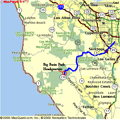
This hike will take place in Big Basin Redwoods State Park - the oldest and one of the largest California state parks.  It has over 80 miles of trails crossing old growth and second growth redwoods, creeks, waterfalls, 
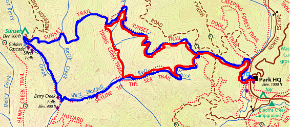
ridges, valleys, mountain peaks, etc.  The trail we will attemp this sunday will be about 10.5 miles long and take 6 to 7 hours.  Why the distance?  Because of what we'll be able to see:  old growth redwoods (super giant redwoods, some over 2000 years old) and several waterfalls (for an example, see this picture:  http://www.bigbasin.org/silvercascadefalls.jpg).   I have been on this loop several times several years ago and it was well worth the distance!  The elevation changes are not drastic like Purisima or Mission Peak, or even Monte Bello.  The expected elevation change is +/- 400 ft (Purisima was 1600 ft, Mission Peak was about 2000 ft, Monte Bello was +/-600 ft), so given a moderate to slow pace, no one should have any problems, including kids.  When I went on this loop several years ago, it was with a group where most were first-timers, including some kids, and everyone finished it.   We will need to bring a light lunch and eat it about half way into the hike, so bring something like sandwiches or whatever you prefer.  We also did this last time I did this loop and I think we had lunch sitting around the waterfalls.

The loop can be cut in about half by taking an alternate trail for those that dont want to do the entire loop.  The shorter loop will be about 7 miles but you will not see the waterfalls.  Both short and long loops start on the same trail, so you'll have about an hour to decide whether to continue on the long loop or take the alternate trail for the short loop.  Either way, it should be beautiful.

Remember, this will be a fairly shady hike so you wont have to worry about exhaustion from the sun. And the altitude change is fairly moderate - probably around the same level as our last Big Basin hike for those that went on that one. 

This hike has already been confirmed, that is, it will take place no matter what :)  Please let me know if you plan to join us by Thursday noon.  We will meet at Bijan as usual, but because it will be a fairly long drive (~1 hr) to the park, please arrive at the Bijan bakery at least 10 minutes before 8 so we can carpool and you can get breakfast or sandwiches for lunch. 

After this hike, we might have another hike the week after (8/26) and then we'll be breaking for Labor Day weekend and possibly the week after that as well.  So this might be the last hike for a few weeks, so come on down!  Take a look at some pictures from last month's Big Basin hike (6 miles) if you want to see what parts of Big Basin looks like: http://y42.photos.yahoo.com/bc/piglettrails/lst?.dir=/Big+Basin+7_14&.view=t
If you have any questions, don't hesistate to let me know.  Hope to see ya all Sunday!

paul


Schedule for this hike:

Trail Information

Park Location:  Off Rt 236 about 15 miles southwest of Rt 9/Rt35 intersection.  About 25 miles from downtown Saratoga.
Trail Name: Trail to Berry Creek Falls
Trails taken for the loop:  Sunset Trail to Berry Creek Falls Trail to Skyline to the Sea Trail Loop Trail.
Trail Location: Opal to Berry Creeks and large undeveloped Mid Park areas.
Distance: ~10.5 miles, optional 7 mile shorter loop.
Elevation change: +200 ft -400 ft, starting elevation is about 1000 ft.
Time: ~5 to 7 hrs, depending on breaks taken.
Difficulty:  Moderate to strenuous
Trail conditions: More shade than sun (75% to 25%, respectively).  No wind to speak of.  Could be foggy in the early morning, generally very comfortable.  Weather information: http://www.bigbasin.org/weather.html
What to see: Opal Creek, many of the largest Old Growth trees (Santa Clara Tree), and Berry Creek (four water falls).
Trailhead: Across the street from Park Headquarters, at the large Redwood Trail Marker, across Opal Creek from the Opal Creek Comfort Station then right.

Park information: http://www.bigbasin.org/
Trail map: http://virtualparks.com/parks/castle-rock-qtvr-map.html
Waterfall picture: http://www.bigbasin.org/silvercascadefalls.jpg


Map/directions
 
Bijan Bakery

The Bijan bakery is in the Saratoga Square plaza (Lions Supermarket).  It is just off 280, a few miles south of 85 and a few miles north of 17.  This is our main meeting place where carpool will be arranged. Unless indicated otherwise, please meet here.

1. From 280 North or South, get off on Saratoga Ave, towards North (from 280 North, it would be right turn, from 280 South, it would be left turn). 
2. Make a left on Kiely Blvd, it is about 1/4 mile from 280.
3.  Make a left into the plaza driveway.  You'll see a store with the sign "Bakery" closest to Kiely Rd.  Burger King is across the parking lot in the same plaze.
4.  We'll meet in front of the bakery, by some outdoor cafe tables.
 

Use this link to get directions from your starting point: Directions

Big Basin Redwood State Park

1. Take DeAnza or Saratoga Ave towards downtown Saratoga.
2. Turn onto Rt 9 towards Big Basin once you get to downtown Saratoga. You will pass through downtown Saratoga.
3.  Go on Rt 9 (all uphill, avg 30 mph) until you hit Rt35, otherwise known as Skyline Blvd. There should be a sign at the intersection for Big Basin.  Cross Skyline/35 and continue on Rt 9 for another 8 miles or so until you see the sign for Rt 236.
4. Get off Rt 9 and get onto Rt 236 (veer to the right off Rt 9).  You'll stay on Rt 236 for about 10 miles - this is a pretty windy road, so just drive slowly.  You will eventually drive into the park and the park headquarters.  The parking lot is just past the headquarters (on the left) on your right. 

If you are meeting us here, please give yourself 1 hr 15 minutes to get to the park from Bijan and wait by park headquarters.  If you are considering meeting us at the park, please do let me know ahead of time, thanks! Email me at pthuang@aol.com

Click on the map on the right to zoom in/out of the area.  Or more information: http://www.bigbasin.org/travelbasics.html

Trail Map
We will star at the park headquarters (middle-right on the picture below) and hike up via the solid blue line on Sunset Trail, then hike along Berry Creeks Falls Trail through Golden Cascade, Silver Falls, and Berry Creek Falls, and then head back via Skyline-To-The-Sea Trail.  The shorter loop cut through via the TImms Creek Trail and is shown in solid read in the picture below.  The shorter loop is about 7 miles.


Notes about this hike

General notes about hiking trips

Probable next hike

-Not planned yet.  Will email in the week of 8/20.
-No hike planned during Labor Day Weekend.


Pictures from previous Big Basin hikes

[Return to SVHikers main page]