Castle Rock/Summit Rock Loop (Sunday 11/25/01)


Subj: [Sun - 11/25] Castle/Summit Rock hike
Date: 11/20/01 4:28:50 PM Pacific Standard Time
From: PThuang
To: svhikers@yahoogroups.com

Dear friends,
 Happy Thanksgiving!  Everyone ready for the long weekend?  Hope you all have a wonderful time with family and friends :)  As I've received some interest in 
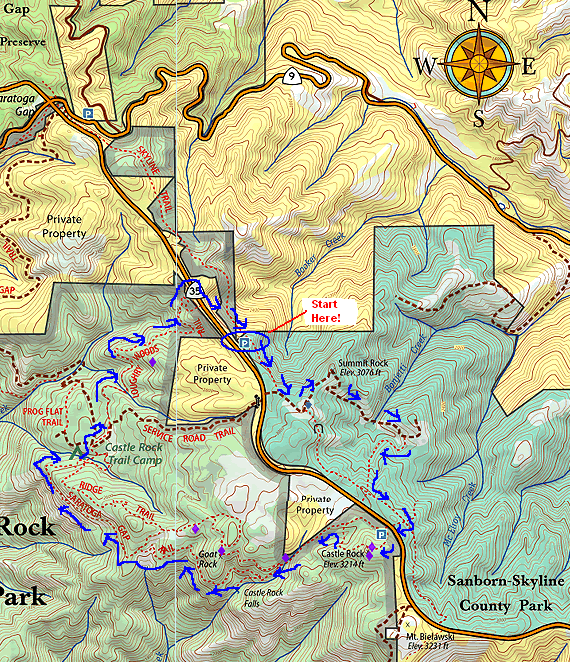
a hike this weekend, let's do a relatively easy hike at Castle/Summit rock.  We last did this hike on 9/9 and several times before that as well.  The hike is pretty close to Bijan and very beautiful and fun!  If you've been on this hike before, you know what I mean, otherwise check out the pictures of previous hikes.  The information for this hike is posted at:
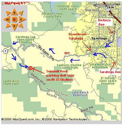
http://www.signite.com/hiking/Pages/Info/CastleRock/112501.html

Notes:
- We can have lunch in Saratoga (pretty reasonable $) or if you want, bring a picnic lunch.  Either way, we'll eat in downtown Saratoga as it's close to the trails and a easy drive after the hike.
- Bring poncho or umbrella in case it rains.  The hike is automatically cancelled only in the case of pouring rain.  Light rain or showers does NOT cancel the hike :)  
- No jeans please, especially for first-timers if you're bringing somebody :)  See the info page for more details on what to wear.

Please let me know if you'll be coming to this hike by Friday morning, the sooner the better though.  Of course you can always join us last minute but it'd be good to know how many are coming ahead of time.

If you took pictures during the last hike and meteor shower event, please email me the pictures when you get a chance.  Unfortunately none of my pictures for the meteor shower came out.  I made a very very silly mistake in loading the film into a camera I hadn't used in years :)  

Thanks and see you all on Sunday!

paul


Schedule for this hike:

Trail Information

Location:  Off Rt 35 (Skyline Blvd), about 2 miles south of Rt 9/Rt35 intersection.  About 10 miles from downtown Saratoga.
Distance: ~7 miles (not very strenuous at all)
Elevation change: +/- 600 ft, starting elevation is about 2500 ft.
Time: ~3 to 4 hrs, depending on breaks taken.
Difficulty:  Moderate
Trail conditions: Excellent combination of shade and sun.  ~1/2 sun, 1/2 shade.  Trails range from single man-width to car-width.  No wind to speak of.
What to see: Excellent views of Silicon Valley on one side (Summit Rock) and Santa Cruz mountains and the Pacific ocean on the other side (Castle Rock trails).

Park information: http://www.bahiker.com/castlerock.html
Trail map: http://virtualparks.com/parks/castle-rock-qtvr-map.html


Map/directions
 
Bijan Bakery

The Bijan bakery is in the Saratoga Square plaza (Lions Supermarket).  It is just off 280, a few miles south of 85 and a few miles north of 17.  This is our main meeting place where carpool will be arranged. Unless indicated otherwise, please meet here.

1. From 280 North or South, get off on Saratoga Ave, towards North (from 280 North, it would be right turn, from 280 South, it would be left turn). 
2. Make a left on Kiely Blvd, it is about 1/4 mile from 280.
3.  Make a left into the plaza driveway.  You'll see a store with the sign "Bakery" closest to Kiely Rd.  Burger King is across the parking lot in the same plaze.
4.  We'll meet in front of the bakery, by some outdoor cafe tables.
 

Use this link to get directions from your starting point: Directions

Summit Rock parking

1. Take DeAnza or Saratoga Ave towards downtown Saratoga.
2. Turn onto Rt 9 towards Big Basin once you get to downtown Saratoga. You will pass through downtown Saratoga.
3.  Go on Rt 9 (all uphill, avg 35 mph) until you hit Rt35, otherwise known as Skyline Blvd. 
4. Turn left on Skyline for about 2 miles.  The Summit rock parking is on your left.  If you pass this, you'll see the Castle Rock entrance a few more miles down, on your right.  Turn back to find Summit Rock parking.  There is space for maybe 10 cars. 

If you are meeting us here, please wait by the trailhead. 

Click on the map on the right to zoom in/out of the area.

Trail Map
We will follow the blue-arrows, starting at the Summit Rock parking lot.  After resting at Summit Rock, we'll proceed to Castle Rock, then follow the Saratoga Gap Trail until we hit the Castle Rock Trail Camp.  There are picnic tables here and we can take a rest.  Afterwards, we'll take the Longhry Woods Trail until we hit Rt35/Skyline.  Then we'll cross Skyline and end at the Summit Rock parking.


Notes about this hike

General notes about hiking trips

Probable next hike

- Undecided


Pictures from previous Castle Rock hikes