Forest Of Nisene Marks State Park
(Sunday 10/21/01)
Subj: [svhikers] [Sun] 10/21
- Forest of Nisene Marks State Park
Date: 10/18/01 12:14:42 PM Pacific
Daylight Time
From: PThuang@aol.com
To: svhikers@yahoogroups.com
Hi All,
Thanks for even more
feedback on the survey - over 15 people have responded already, with similar
comments. We'll consider all individual preferences and work something
out so everyone can enjoy.
Sorry I haven't had
a chance to post up the usual information page on the upcoming hike.
Please check it tomorrow and perhaps print it out for reference, directions,
etc. So far, it looks like there'll be perhaps a dozen folks on this
hike. Let me know if you haven't already if you're coming, thanks!
Until the info page comes out, these
are the details:
1. We'll leave Bijan at
7:45AM, so please show up around 7:30AM! This is
because of the location of the park - it's a bit farther to drive - a little
over an hour on Rt17. PLEASE BE ON TIME!!!!!!!!!!!!!!!!! PLEASE!!?!!
:)
2. Bring sweatshirt in case it's
chilly.
3. Bring light lunch - we might
be having it while hiking. There are lots of small town places we
can visit after the hike. But the hike will last till probably 2pm
so please bring a light lunch.
4. There will be TWO (2) hikes,
both in the same park, but separated by a 10 minute drive. The first
hike is a quickie - just 1 mile and on flat grounds. There are some
interesting things to see on this short hike. After the first hike,
we'll drive farther into the park, for about 3 miles, and start the second
hike. The second hike will be around 6-7 miles and may be like Purisima
although not with as much altitude. Expect around 1,000 ft climb
altogether. On this second hike, we'll see the 1989 Loma Prieta earthquake
epicenter. (Did you know 10/17 was the 12th anniversary?) We'll
also see a lagoon and old wood mills. It'll be interesting.
We may have lunch at the lagoon.
5. After the hikes (2-3pm),
we can explore the nearby towns. There are 1) Aptos, 2) Soquel, and
3) Santa Cruz.
paul |
Schedule for this hike:
-
7:30 AM. Meet at Saratoga Plaza
(Lions Plaza), outside the french Cafe/Bakery (Bijan). Exact address
is 441 Saratoga Ave, San Jose. It's just off 280 and Saratoga
Ave. See map information below for more details. We will determine
carpool arrangements if necessary.
-
7:45 AM. Leave for Forest of Nisene
Marks State Park. It'll take about an hour and 10 minutes to get
there.
-
9:00 AM. Park at the first parking
lot and start hike #1. This is a easy 1.1 mile hike, will take no
more than 30 minutes.
-
9:45 AM - 10:00 AM. Drive further
up Aptos Creek Road to the Porter Family Picnic Area, park, and start hike
#2. This is a 7 mile loop with about 1,000 ft elevation gain.
We'll take the Aptos Creek Trail through the 89 earthquake epicenter.
-
12:00 PM. Picnic at White's Lagoon,
which is half way through the hike.
-
2:00 PM. Get back down to the
parking area. Explore area towns or whatever you'd like!
Trail Information
Park Location: ~7 miles
south of Santa Cruz, about 3 miles off Rt 1, in the town of Aptos.
Trail Name: Aptos Creek Trail,
among several others.
Trails taken for the loop:
Two sets of hikes involving many different trails (see trail map below)
Distance: Hike #1: 1.1 mile,
Hike #2: 7 miles. Total of about 8 miles.
Elevation change: +/-1,000
ft, starting elevation is about 300 ft.
Time: ~5 to 7 hrs, depending
on breaks taken.
Difficulty: Hike #1:
very easy, Hike #2: moderate
Trail conditions: Lots of
shade through redwoods and creeks. Weather information:
Aptos,
current forecast is for 67F on Sunday.
What to see: Lots of
stuff: twisted redwoods (you'll wonder how they became that way), flowing
creeks, giant and not-so-giant redwoods, bikers and joggers and hikers,
old mill sites, old railroad trails, the 1989 Loma Prieta earthquake epicenter,
Whites Lagoon (where we'll have lunch), and bunch of other things, and
oh, I didn't even mention visint the nearby towns afterwards!
Park information: http://www.mbay.net/~mzelus/nisene.html
(pictures only, there's no official site)
Trail map: see below
Map/directions
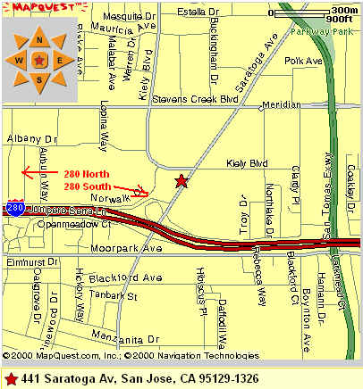
| Bijan Bakery
The Bijan bakery is in the Saratoga
Square plaza (Lions Supermarket). It is just off 280, a few miles
south of 85 and a few miles north of 17. This is our main meeting
place where carpool will be arranged. Unless indicated otherwise, please
meet here.
1. From 280 North or South, get off
on Saratoga Ave, towards North (from 280 North, it would be right turn,
from 280 South, it would be left turn).
2. Make a left on Kiely Blvd, it
is about 1/4 mile from 280.
3. Make a left into the plaza
driveway. You'll see a store with the sign "Bakery" closest to Kiely
Rd. Burger King is across the parking lot in the same plaze.
4. We'll meet in front of
the bakery, by some outdoor cafe tables.
Use this link to get directions from
your starting point: Directions. |
 |
Forest of Nisene
Marks State Park
(See trail map below to see where
we will park for hike #1, all parking is right on Aptos Creek Road)
-From Bijan, take 280 South and then
get onto Rt 17 South.
-Drive about 26 miles on Rt 17 until
Rt 1. Get onto Rt 1 South - towards Watsonville/Monterey, NOT Santa
Cruz.
-Stay on Rt 1 south for about 6
miles and then take the Seacliff Beach/Aptos exit. Keep left at the
fork in the ramp and turn left onto State Park Drive.
- From State Park Drive, turn right
onto Soquel Drive. You'll go through an underpass (of a railroad),
then you'll see the railroad track on your left. Make a left onto
Aptos Creek Road. You will cross the railroad tracks rightaway.
-On Aptos Creek Road right after
the tracks, it'll look like the road ended but keep going and you'll pass
through some residential. The road is not so smooth at place.
Keep going for about 2 miles and you'll arrive at the park entrance and
then a parking area to your left. Park here for the first hike.
If you are meeting us here, please
give yourself 1 hr 15 minutes to get to the park from Bijan and wait by
the first parking area (marked "Entrance Station" as seen in the
trail map below). If you are considering meeting us at the park,
please do let me know ahead of time, thanks! Email me at pthuang@aol.com
Click here
to get the directions to Aptos Creek Road from Bijan, or click on the image
on right. |
 |
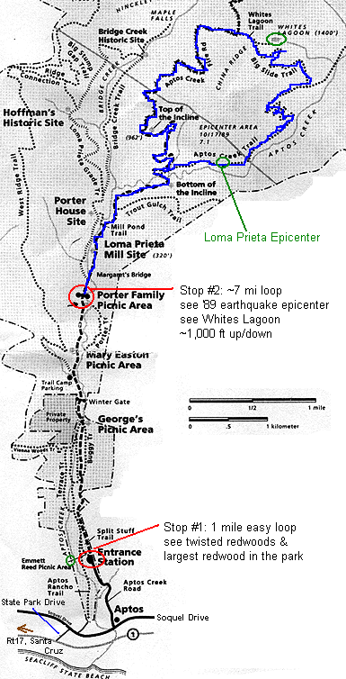
| Trail Map
There will be TWO (2) hikes, both
in the same park, but separated by a 10 minute drive.
The first hike is a quickie - just
1 mile and on flat grounds. There are some interesting things to
see on this short hike. We will park by the lower red circle as shown
in the picture to the right, indicated by "Entrance Station". The
trailhead for hike #1 starts right here.
After the first hike, we'll drive
farther into the park, for about 3 miles, and start the second hike.
This short drive will take 10 minutes as it is a dirt road and we'll have
to drive slowly.
The second hike will be around 6-7
miles and may be like Purisima although not with as much altitude.
Expect around 1,000 ft climb altogether. On this second hike, we'll
see the 1989 Loma Prieta earthquake epicenter. (Did you know 10/17
was the 12th anniversary?) We'll also see a lagoon and old wood mills.
It'll be interesting. We will have lunch at the lagoon. We
will park by the upper red circle as shown in the picture to the right,
indicated by "Porter Family Picnic Area". The trailhead for hike
#2 starts right here. We'll go on the loop as indicated in blue:
Aptos Creek Fire Road to
Aptos Creek Trail, then to Big Slide Trail where we'll have picnic at Whites
Lagoon, then head west and back to parking via Aptos Creek Fired Road (past
the Top of the Incline).
|
 |
Notes about this hike
-
Bring 2 to 3 bottles of water.
Bring light lunch that's easy to carry- we'll be eating it about half way
through the hike (Whites Lagoon).
-
Wear shorts and tee-shirts. Bring
sweatshirts and sweatpants just in case it's cold. But as with other
hikes, you'll warm up pretty quickly once we start hiking, especially on
uphills, and we will have a uphill stretch in hike #2.
-
Please be on time for this hike - it'll
take over an hour to get to the park so we need to start early. We
will leave Bijan by 7:45 am!
-
We will be driving on Rt 17, a winding
road if you're not used to it. Make sure you are able to drive Rt
17 or carpool with someone that can. If you get motion sickness,
you might want to take some medicine with you. Once we get to Rt
1 via Rt 17, the road to the park is not curvy at all, so it's just Rt
17 you might have to think about a bit.
-
If you have any questions, email me
(pthuang@aol.com) or call me at (650)
814-1169 (cell).
General notes about hiking trips
-
1 to 2 bottles of water (I'll have extras
if you forget)
-
Suntan lotion (I'll have a bottle)
-
Snacks - dried fruits, granola bars,
etc.
-
Sturdy shoes - hiking shoes or sneakers
-
Sweatshirt/jacket (in case), sweatpants
or shorts
-
Hat (for sunny hikes)
-
Money (for food if wanted)
Probable next hike
- Halloween hike/get-together: Saturday
10/27/01. Most likely an afternoon hike following by potluck.
Pictures from previous Forest
of Nisene Marks State Park
- First time.
The following are not my pictures,
I'm hereby acknowledging the sites that actually hold these pictures by
placing links on the pictures. I hope they are ok with my displaying
the pictures here. Please click on the pictures to see where they
originated.
2001
SVHikers. Post
or read a
comment.

